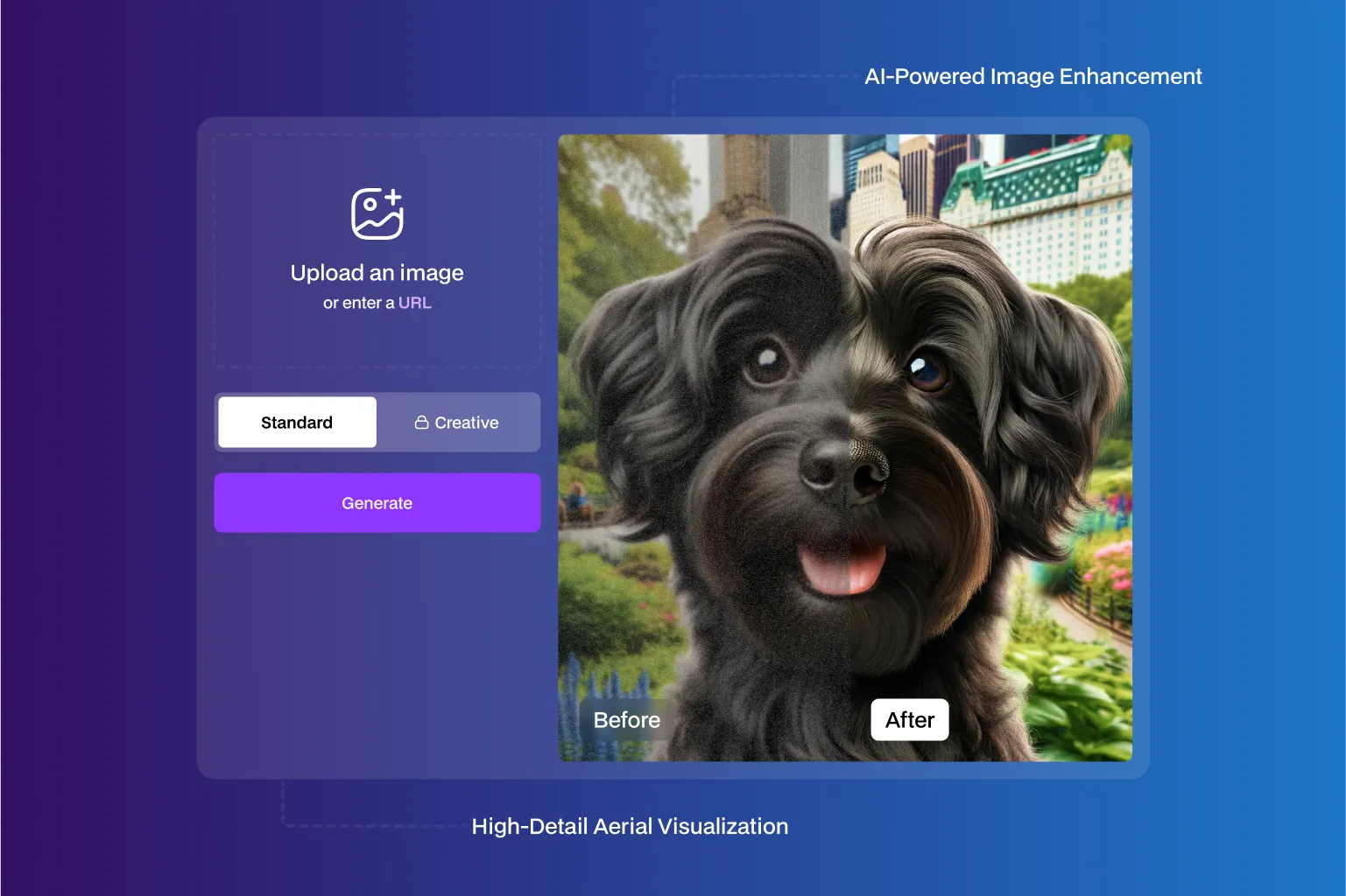
AI Super-Resolution Platform Enhances Aerial Image Clarity by Up to 4× and Improves Analytical Accuracy by 35%
Improved aerial image sharpness by up to 4× and increased usable visual detail by 30–40%, based on observed impact from advanced super-resolution and HDR enhancement workflows in remote sensing and surveillance.
Super Resolution
Technologies Used

Infrastructure
USP
Super-Resolution Advanced RCAN is a next-gen AI platform that transforms blurry, low-resolution aerial images into high-quality, high-fidelity visuals. Tailored for professionals in remote sensing, surveillance, and environmental monitoring, it offers unmatched clarity and detail. Unlike cloud-reliant tools, it runs entirely on-premise, ensuring data privacy and total control. With an intuitive setup, flexible training, and precise output—even in complex image scenarios—this platform redefines aerial imaging by turning limitations into new possibilities for analysis, planning, and decision-making.
Problem Statement
Business Problem
High-resolution aerial imagery is essential for accurate analysis, monitoring, and decision-making. However:
- Capturing native high-resolution aerial images is expensive and logistically complex
- Existing super-resolution methods struggled with blur, atmospheric noise, and motion artifacts
- Low-quality inputs limited analytical accuracy and downstream insights
- Cloud-based solutions raised data privacy and deployment constraints
These limitations reduced the value of aerial data for mission-critical use cases such as surveillance, environmental monitoring, and infrastructure planning.
Solution
Solution
NeuraMonks developed an advanced AI-driven image enhancement platform using Super Resolution, Fake HDR, and True HDR techniques, purpose-built for aerial imagery.
What we delivered:
- Custom-tuned Advanced RCAN architecture optimized for aerial image super-resolution
- AI-based enhancement pipeline handling blur, lighting variance, and atmospheric distortion
- Super-resolution workflows delivering up to ~4× perceived sharpness improvement
- Fake HDR and True HDR techniques to enhance contrast, depth, and visual clarity
- Fully local, deployable solution ensuring data privacy and operational control
This transformed low-quality aerial images into high-fidelity, analysis-ready visuals.
Challenges
Challenges Solved
Blur & Motion Artifacts:
Addressed motion blur from aerial platforms through architectural refinement and model tuning.
Atmospheric Disturbance:
Improved robustness against haze, lighting variation, and atmospheric noise.
Accuracy vs. Performance:
Balanced high-fidelity enhancement with near-real-time processing requirements.
Model Architecture Limits:
Modified and optimized RCAN to outperform standard super-resolution baselines.
Usability:
Delivered a practical, professional-grade tool without compromising interface simplicity.
Why Neuramonks
Why Choose us
- Outcome-driven AI delivery focused on measurable visual and analytical improvement
- Deep pre-GPT era expertise in computer vision and image enhancement
- Production-grade model architectures refined for real-world aerial data
- Strong capability in on-prem and offline AI deployments
- Cost-efficient solutions eliminating recurring cloud processing expenses
- Domain understanding across surveillance, remote sensing, and environmental analysis
Ready to get started?
Create an account and start accepting payments – no contracts or banking details required. Or, contact us to design a custom package for your business.

Empower Your Business with AI
Optimize processes, enhance decisions, drive growth.

Accelerate Innovation Effortlessly
Innovate faster, simplify AI integration seamlessly.